Nordeste, Azores
Nordeste | |
|---|---|
 | |
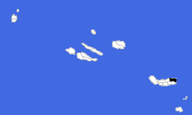
 Location of the municipality of Nordeste in the archipelago of the Azores | |
| Coordinates: 37°49′58″N 25°8′47″W / 37.83278°N 25.14639°W | |
| Country | |
| Auton. region | Azores |
| Island | São Miguel |
| Established | Settlement: c. 1514 |
| Parishes | 9 |
| Government | |
| • President | António Miguel Borges Soares |
| Area | |
| • Total | 101.47 km2 (39.18 sq mi) |
| Elevation | 138 m (453 ft) |
| Population (2011) | |
| • Total | 4,937 |
| • Density | 49/km2 (130/sq mi) |
| Time zone | UTC−01:00 (AZOT) |
| • Summer (DST) | UTC±00:00 (AZOST) |
| Area code | 292 |
| Patron | São Jorge |
| Local holiday | Monday closest to July 18 |
| Website | http://www.cm-nordeste.pt |
Nordeste (Portuguese pronunciation: [ˌnɔɾˈðɛʃtɨ] ; Portuguese for northeast, hence that part of the island) is a municipality on the northeastern part of São Miguel Island in the Azores. The population in 2011 was 4,937,[1] in an area of 101.47 square kilometres (39.18 sq mi).[2]
Geography
[edit]
The municipality Nordeste covers the northeastern part of the island São Miguel. It is the least populated on the island of São Miguel, and most of its interior is covered forests, mountainous peaks and river-valleys, punctuated by fertile pastureland. The highest elevations in this region include Pico Redondo (980 metres), Pico Verde (927 metres), Pico Bartolomeu (887 metres) and Pico da Vara (1103 metres), the highest point on the island of São Miguel.
Administratively, there are nine civil parishes in the municipality:
- Achada
- Achadinha
- Algarvia
- Lomba da Fazenda
- Nordeste
- Salga
- Santana
- Santo António de Nordestinho
- São Pedro de Nordestinho
The parish Nordeste has a population of 1,341 (2011) and an area of 23.13 square kilometres (8.93 sq mi).
Sports
[edit]The following sports clubs are located in Nordeste:
References
[edit]External links
[edit]- Fajã do Araújo
- Lombo Gordo
- Atlântico Nordeste. Migrações (Book)
- Official geographic portal : https://sigweb.cmnordeste.pt


